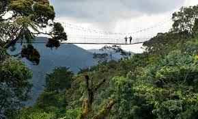
Forest
Rwanda forests and woodlands can be classified into four categories: the natural forests of the Congo Nile Ridge comprised with Nyungwe national park Gishwati, and Mukura; the natural forests of the Volcanoes national park; the natural forests in the savannah and gallery-forest of the Akagera national park and remnants of gallery-forests and savannahs of Bugesera, Gisaka and Umutara; and forest plantations dominated by exotic species (Eucalyptus sp, Pinus sp, Grevillea robusta) and trees scattered on farmlands (agroforestry) and along anti-erosion ditches.
According to a recent mapping inventory, carried out for forests with a surface of 0.5 hectares or higher and with coverage of more than 20 per cent, the forests of the country were estimated at 240,746 ha in 2007. This translates to approximately 10 per cent of the surface of the national dry lands (23,835 km2) (MINITERE and CGIS-NUR 2007). However forest resources in Rwanda include also small woodlots and agro-forestry resources.
Table 1 shows the forest classification in Rwanda, based on the national inventory of forest in Rwanda. This classification shows that humid natural forests constitute the majority of the forest cover in Rwanda (33 per cent), followed by Eucalyptus plantations and degraded natural forests at 26 and 15.7 per cent respectively (MINITERE and CGIS-NUR 2007.
![]()